


Garmin Colorado: A New Perspective for Outdoor Sports Lovers

Garmin has unveiled its latest outdoor GPS, the Colorado 300. Combining revolutionary solutions and practicality, the device is sure to be a favorite of outdoor sports and fitness enthusiasts.

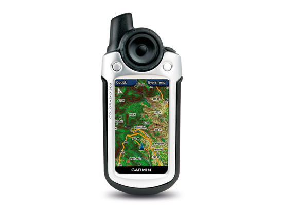
The Garmin Colorado is a universal GPS device that provides accurate directions, either while sailing or on top of a mountain. Its high-sensitivity GPS receiver, world-wide terrain-shaded base map, and brightly colored, high-resolution 7cm screen provide reliable outdoor navigation at all times, regardless of the weather.
"Whether you're climbing a mountain, fishing on an unknown river, or taking a geocaching tour with your family, Colorado brings its unknown surroundings to life in unprecedented detail." Said Dan Bartel, Garmin's vice president of international sales. "While Colorado offers plenty of new features and customizable options, the device is extremely easy to use with the brand new, patented Rock 'n Roller."


The Garmin Colorado has been specifically developed for outdoor sports and fitness activities, so its waterproof cover and down weight do not hinder the user during any activity. Weighing just 20 dkg, the device can be used with two AA batteries for 15 hours, making it the perfect travel companion for a longer trip. Its electronic compass and barometric altimeter make it impossible to get lost. The Colorado also displays air temperature and optional heart rate monitor or speed and pedometer.


User profiles for maximum customization
Colorado is the first Garmin device to customize five profiles - car, water, leisure, fitness and geocaching. With these custom settings, we can easily access the features that are most needed. Ease of use is also ensured by the revolutionary Rock 'n Roller wheel, which can be easily turned with a thumb, so the navigation device can be used with one hand.


The Garmin Colorado has an SD card slot, so it supports uploading a variety of detailed MapSource maps to further enhance the security of your navigation. By adding topographic data, hikers can enjoy ultra-modern, three-dimensional elevation display, and by uploading street data, they can experience the most detailed navigation, even in a car or bicycle. Colorado also supports communication with others, allowing users to share routes, terrain, and geocache data wirelessly. And at home, every program loaded with Colorado can be relived by downloading and playing tour data to a PC.

Garmin Colorado 300 - Features
-
Size: 6.0 13.9 x 3.5 cm
-
Display: 3.8 x 6.3 cm, 7.6 cm diagonal, 240 x 400 pixel transflective TFT
-
Weight: 206.9 grams with batteries • Batteries: 2 AA or 2 NiMH batteries (not included)
-
Battery life: 15 hours • Waterproof: yes (IPX7)
-
High sensitivity GPS: WAAS / EGNOS prepared
-
PC connection: USB
-
Maps and memory: built-in base map with terrain shading, 384 MB of usable memory
-
SD card expansion option
-
Waypoints / Favorites: 1000 can be stored
-
Route: 50 can be stored
-
Trail: 10,000 points, 20 savable trails
-
Turn-by-turn route planning (requires a detailed map to support this)
-
Electronic compass, barometric altimeter, thermometer
-
Other features: Geocaching mode, GPS games, Fisherman / hunter database, Astronomy database, Price / Tide database support, area measurement, own POI database support • Wireless data exchange option
-
Optional pedal and heart rate monitor connection


